
NORTH to ALASKA
North to Alaska: A Cessna 180 Adventure
North to Alaska: An Epic Cessna 180 Adventure from Phoenix to Wasilla
By Joe Pendergrass and Jim Davis, West Valley Flying Club Phoenix
The Journey Begins
Dawn broke with clear air and unlimited visibility as we loaded the Cessna 180 with winter survival equipment including warm clothing, rain gear, small bags and snacks for the trip north. The number of seats was reduced to two due to the cargo load for the trip, and Joe Pendergrass, PIC, had carefully prepped his aircraft and flight plan. Jim Davis was riding shotgun as co-pilot for a three day run to Wasilla, Alaska.
Takeoff from Glendale Airport Phoenix (KGEU) on 12 April 2024 at 0635 local time for an estimated journey of 22 hours in the air with two overnight stops. The original takeoff date had been set for 15 April but due to the severe clear weather forecast, Joe, the pilot in command, called for a three day earlier start. Why waste good weather in the north while sitting on the ramp twiddling our thumbs in Arizona? The trip was a go but later in the far north Yukon Territory the weather changed including sleet, snow and low (zero) visibility. This weather added an extra day to the trip.
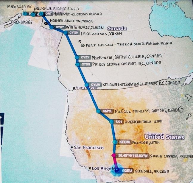
The intended flight track was about 2,500 nautical miles through Arizona, Utah, Idaho and the interior of British Columbia Canada and the Yukon to Anchorage and Wasilla, Alaska.
Trip Stats: Flying from Glendale, Arizona to Wasilla, Alaska: 10 Stops included 9 fuel, 19.5 flight hours, and 4 days with one day weather delay, 3 nights in motels.
Issues: Grounded one day (18+ hours) at Haines Junction, Yukon Territory due to IFR weather. One flat tail wheel tire while taxiing in Palmer, Alaska waiting snow removal from runway at “The Penderosa” in Wasilla, Alaska which is Joe Pendergrass’s home airstrip.
Memories: Priceless.
Day One: Arizona to Utah
After completing the routine pre-flight checks, the aircraft loaded and full fuel (55 gallons), we were ready to head north in the cool morning air. We lifted off quickly at 0635 local time on April 12, 2024 and climbed out over Sun City, Highway 101 and Lake Pleasant as the early morning sun filled the sky. The air was calm and the flight toward Northern Arizona was smooth. Our route took us above Prescott, Williams, crossing Highway 40 and through the corridor above the Grand Canyon one hour and 22 minutes after takeoff. The canyon was beautiful, a spectacular sight with the sunshine lighting up the sharp ridges of the north rim and shading the dark valleys below on the western portion of the Grand Canyon. We crossed the Arizona/Utah border over snowcapped mountains and along river valleys.
First fuel stop: Fillmore City Airport, Utah (KFOM) – Another quiet non-towered airport had us taxiing on both sides of the runway looking for the self-serve fuel pump. A pilot lounge was located nearby with the airport manager who said this wasn’t his day job even though it was daytime, but was very pleasant fellow who eagerly showed us his two airplanes parked in the hangar. One was a C-182 and the other was an experimental (wanna’ be cub) that he would soon be hunting wolves with. There was an earlier picture on the wall showing several wolves taken in a previous hunt and lying in front of a Super Cub with the hunters and rifles. A nice 30 minute stop.
Second fuel stop: American Falls (UO1), Idaho – Another quiet non-towered airport had us taxiing on both sides of the runway looking for the self-serve fuel pump. A pilot lounge was located nearby with the airport manager who said this wasn’t his day job even though it was daytime, but was very pleasant fellow who eagerly showed us his two airplanes parked in the hangar. One was a C-182 and the other was an experimental (wanna’ be cub) that he would soon be hunting wolves with.
Day Two: Idaho to Canada
Takeoff to McCall, Idaho (KMLY)
Takeoff was on runway 03 headed Northwest toward McCall, Idaho. As we crossed the mountains, we began to pick up light turbulence (as noted by Joe) but it seemed to Jim it was more than light. Joe is the one who’s been flying this 180 for 40 years and he should know light from moderate so I’ll go with Joe’s estimate. Joe told me to not fight the rolls with the ailerons (Jim flying), but just “roll with it back to level flight.” It was hard to find level flight in this ‘light turbulence.’ Oh well, light it was, however later the turbulence was a “head banger” according to Joe and I’m not sure if that’s above ‘moderate turbulence’ or not. Joe thinks knowing the difference is to be there and feel it to decide. It was rough air no doubt about it. April is not the ideal month to fly through the mountains of Idaho, British Columbia Canada, the Yukon Territory and Alaska.
Early afternoon we touched down at McCall, Idaho in clear, cold air with no turbulence for our first RON. Joe recognized his friend on the ramp as fellow Iditarod pilot, Jerry Wortley, a retired insurance adjuster who splits his time between Alaska and McCall, Idaho. He had invited Joe to stop and visit on our way north and had been tracking our progress through a program similar to Foreflight. Jerry gave us a ride to the Best Western motel across the street from the airport and then a tour of McCall (which took maybe 3 minutes at the most), a quick lunch and then to his beautiful log house perched on the side of a heavily treed hill with a stunning view of the valley below about 12 miles from the airport. Since flying was done for the day, we sat in the sun on the deck with a couple of beers reminiscing about flying the Iditarod. Jerry got a call from the FBO (Jake at Dew Aircraft) that a thunderstorm with hail was expected that night therefore our airplane had been put in their hanger for the night. Absolutely great hospitality! They even left a key outside the hanger for us to get in if we decided to leave early in the morning. Of course we always leave early due to a calmer morning air. The overnight rain stopped about 0500 and blue sky’s greeted us before 0600.
Day Three: Into Canada
Day two started by filing a flight plan to cross the International border into Canada. Canpass (Canada Passport) was called and the EAPIS (Electronic Advance Passenger Information System) was filed as required. We were good to go and rolled the 180 out of the hangar onto the ramp. Takeoff was a little before 0600.
The thunderstorm in Idaho had passed during the night and we had sunny skies and occasional light turbulence (…right…) for the first two days. Today’s route of flight was direct from McCall, Idaho to Kelowna, British Columbia. This was approximately 330 nautical miles planned for a 2.8 hour flight. Joe’s plan was to use a ground speed of 120 knots which would allow a little wiggle room and could easily be adjusted for wind to match our flight plan. The Canadians like flyers to be precise.
This course took us over Lewiston, Idaho and west of Spokane, Washington through the Roosevelt MOA with the cross into Canada about 28 NM east of Dorothy Lake Airport with Jim on the controls crossing the international border. After crossing the border there was 62 miles remaining to the Kelowna airport (KYLW). Kelowna is a beautiful city (from about 1,000 feet on final) with 160,000 residents and sits on the bank of Okanagan Lake. The airport is somewhat of a busy place with scheduled airlines offering service as well as several smaller companies.
Joe radioed the tower saying we needed to clear customs and was instructed to call them from his cell phone while remaining in the plane after landing. The customs agent who answered the phone verified some routine information before giving Joe a number. This number was our clearance from Canadian customs and then he said “…we were free to carry on.” We were given a discrete transponder code similar to flight following procedures used in the U.S. No customs officials visited us at our airplane. So, much for tough Canadian customs inspections. More info on the U.S. customs in Alaska to follow…
After filing the mandatory flight plan in Canada, we were cleared for takeoff northwest bound for MacKenzie (CYZY) British Columbia. This leg is about 348 nautical miles and takes us east of Kamloops, over Williams Lake and Prince George. After landing MacKenzie, Joe tried to close our flight plan as scheduled but could not get any answer on any of the frequencies. So, after refueling at this non-towered airport we took off anyway flying up the “trench” hoping to file in the air for Whitehorse, Yukon Territory.
The commonly referred to trench is a valley that leads directly to Lake Watson, where we began paralleling the Alcan Highway. The southeast end of the trench is dominated by Williston Lake that extends approximately 100 miles and is used by logging companies in the summer for floating logs to the mills. Most of the lake was still covered with ice this time of year. About 30 miles up the lake, we received a call from Whitehorse radio on the “Canadian Enroute” frequency (126.7) to inform us they knew we were in the air (by our assigned transponder code) but wanted to make sure we were ok since we didn’t close our flight plan in MacKenzie. Joe explained our attempts, they acknowledged, and then Joe asked to file an inflight plan to Whitehorse for five hours with a stop at Lake Watson. They said ok, we’ll give you 30 minutes for a fuel stop there. A good plan Joe accepted.
Day Four: Weather Challenges in the Yukon
Joe filed a flight plan to Whitehorse, Yukon Territory (CYXX) because he didn’t want to get stuck in Lake Watson (CYQH), if we could avoid it. There were no overnight accommodations near the airport and a cab ride into town was $75 each way, but in Whitehorse all we had to do was walk across the Alcan Highway from the airport to a motel. At that point we had plenty of daylight to make Whitehorse. Upon arriving in Watson Lake, we taxied to the self-serve fuel pump and when Joe completed the credit card info, the fuel pump machine indicated the pump was not in service. A little panic began to set in because there was nowhere else to get fuel and the amount of fuel we had remaining would not allow us to reach Whitehorse, or anywhere for that matter. Also, we needed to fuel without losing daylight. A problem fix was needed immediately. The flight station operator offered a card from some local company to try. It did not work either. Then the station operator rebooted the computer, and it remedied the situation. Fuel is now available. If that had not worked, we might have had to cancel the flight plan to Whitehorse and no telling how long we’d be stuck in Lake Watson waiting to fuel. We might still be there!
Then when our direct flight to Whitehorse was accepted another problem presented itself on our climb out from Lake Watson. The weather began to deteriorate as the clouds began to thicken up. If it’s not one thing, it’s another. The direct flight is about 186 nautical miles but we were not able to maintain a straight line course because the clouds got lower and we began to make a circuitous course dodging and dancing among the mountain tops covered by clouds. The terrain was mountainous (everywhere since Idaho) and we deviated from our desired course by a number of miles seeking a clear VFR path.
We found our way to the Alcan Highway and were able to follow it to a spot where the weather lifted when we again got a call from Whitehorse radio. They were watching our progress on radar and asked if we’d like to extend our flight plan since it was about to expire. Joe told them we were 15 minutes out with good visibility and a good ceiling. We landed at the Whitehorse Airport, canceled our flight plan and were directed to the self-serve fuel pumps, and then to parking at the base of the tower. We tied the plane down, gathered our overnight belongings and headed to one of the motels across the Alcan Highway. We chose the Airport Chalet because it had a restaurant (and a bar) in the building. An older place but adequate and a popular stop for those traveling the Alcan Highway. We could view the Alcan Highway as we ate. Not much traffic. Day two completed.
Day Five: Weather Forces Another Delay
On day three we got up to a weather forecast showing a high overcast of 24,000 feet in Anchorage and solid VFR conditions in Whitehorse with only a slight breeze. We ate breakfast, Joe filed our flight plan, updated the EAPIS and called the U.S. Customs for our direct flight to Northway, Alaska. A direct flight of 238 nautical miles was planned from Whitehorse which was shorter than following the Alcan. The route would take us over Beaver Creek, Yukon Territory before crossing the International border to meet U. S. Customs in Northway, Alaska.
Soon after takeoff weather problems began to plague us as we flew northwest over the first mountain range toward our destination. Cloud cover became lower… and … lower …and lower. We could still see blue sky above in spots so we decided to go “on top.” Once to 12,500 feet, we could see many of the clouds were much higher and opted to descend to get around them through the canyons below if weather permitted. We headed northwest in the general direction of Northway, Alaska and then to the southwest. We had filed for a two hour flight and gave the customs the required notice of our expected arrival to Northway. The U.S. Customs officer had to drive for about 50 minutes to Northway which was the nearest U.S. airport for us to clear U.S. Customs, but we had plenty of daylight.
As we descended from 12,500 feet the clouds went all the way to the ground in many areas as light snow began to pepper us. We made at least three 90 degree turns as we wound around the mountains seeking a better route. We decided to make our way south back again toward the Alcan Highway and follow it to the border of Alaska. The highway was about 42 miles from our present position southwest and the weather looked better in that direction. After more twisting and turning seeking an acceptable VFR route, we cleared one set of mountains and picked up the Alcan Highway. However, the highway led into another set of mountains shrouded by clouds all the way down to ground zero. Joe knew the highway ran through Haines Junction and somewhat suddenly, an airfield appeared some distance away and it seemed to be calling us because we could see it! What Jim thought was a black asphalt runway almost shining with white clouds and snow all around, and green trees swaying in a stiff breeze, the runway clearly stood out directly in front of us as if beckoning us to land! A look to the north showed snow showers and extremely limited visibility toward Kluane Lake which is where we needed to go. The decision was an easy one; Joe reduced power and made a three mile straight in approach to the only runway in rugged terrain near the highway. We were out of options; there were no other promising solutions even back to Whitehorse which we were told by radio, it was “closing in.”
On landing the runway turned out to be hard pressed gravel, not asphalt, and as we taxied just beyond the trees we saw the sign, Haines Junction, Yukon Elevation: 2150, above the terminal door. Now we knew exactly where we were. We taxied to the very lovely and lonely outpost with clouds blowing in as we taxied. At least we were safe on the ground and knew where we were. The terminal was quickly being wrapped in the whirling snow, and it was closed. There was nobody manning the terminal and we were in the Yukon wilderness in 20-degree weather, but alas, the problem was now much simpler being on the ground intact and sitting in an airplane we could fly out when the weather cleared. Really nice. Life turned back to being very good.
The day was Sunday, 14 April, our expected arrival day in Alaska and there was nobody anywhere in sight in the Yukon, only low clouds and snow. There a locked hanger we investigated and several small buildings with three small planes tied down with engine covers on them. Joe called for weather on the radio and learned within 30 minutes the snow would be upon us, however, it already was as we sat in the airplane which had been shut down for 15 minutes. Weather changes fast in these parts and heavier snow was arriving sooner rather than later. So we decided to stay put and see what tomorrow would bring.
Joe called U.S. customs on his iPhone to cancel the customs agent’s drive to Northway and closing our Canadian flight plan for today due to weather. The customs agent in Alaska was appreciative for the call since he was just about to leave on the 2-hour round trip drive to meet us. Joe would refile tomorrow morning, or when the weather cleared. Also, it was interesting that we received a radio call from the Canadian enroute control to tell us our flight plan was about to expire and asked for our intentions. We were sure they called after losing radar contact with us in the mountainous area after we left 12,500 feet looking for a lower route through the mountains and disappeared from their radar when we went below the mountain tops. Joe canceled our flight plan and told them we would refile tomorrow weather permitting.
Now, what about tonight? It was cold, about 30 degrees going to 20 with small blowing snow crystals. Joe had 2 parkas in the airplane survival gear and Jim quickly put his on not wanting to freeze to death before the next event whatever that was going to be. Joe put on his parka and ‘bunny boots’ purchased from war surplus years before. We tied the 180 down and took our gear to the only small, unlocked shelter room which was part of the terminal. Joe plugged in the 180’s engine to an electrical heating plug into an extension cord hanging on the post where we tied down. Joe doubted it worked.
Day Six: Breaking Through to Alaska
The flight on the fourth day worked out well after pulling the prop through a couple of times, disconnecting the electric heater cable to the engine that Joe was sure didn’t work, and the C-180 cranked right up after a cold night. The weather forecast was VFR the entire route. In the no wind morning Joe chose runway 23 for takeoff and with a slight bank to the north followed the Alcan Highway toward the ice covered Kluane Lake in gorgeous weather. We flew over Destruction Bay, Burwash landing and Beaver Creek, our designated border crossing point to Northway, Alaska. Jim was again at the controls as we crossed the international border this time to Alaska.
Joe had to time our arrival to Northway, Alaska carefully because U.S. Customs required us to be there no earlier than 10:00 a.m. and not to get out of the aircraft if the customs official was not present—”stay in the aircraft!!!” Jim figured there might be a SWAT team with automatic weapons there to ensure we weren’t invading one of the United States in a Cessna 180! Joe had amended our EAPIS with a fresh, new ETA that morning. The weather forecast was severe clear and we landed at 10:15 a.m. and began looking for our customs official since this was a non-towered airport and again, there was no one about—it’s a very small place. Most of the populated places in the far north do not have recognizable features like smoke stacks, railroad tracks, crossing freeways, 18 wheelers, and other such outstanding characteristics to set it apart from the snow covered fields and frozen lakes. Mountains, snow and trees is about all you’ve got up there so the landscape is well camouflaged hiding small manmade structures.
However, on landing and identifying the customs officials in the only car in sight with blue and white customs designations parked near the runway, we taxied up to his car and shut down. He was a nice enough old guy that checked our credentials, passports, pilot’s license and the airplane. The customs official used a device about the size of a laptop going over every part outside of the airplane as if it was a preflight of some sort. He never looked inside or checked the boxes covered in blankets behind the only two seats in the plane. No one knew what ole Joe had under those blankets and the customs guy didn’t seem to care. Found out later the device he had may have been to detect radioactive materials! What did they think we might have—an atomic bomb in a C-180? That must be what they check for on our southern border for those millions of illegals that are continuing to come in to the U.S.A. Does any of this make sense?
As usual it was a Monday morning, our fourth day, and the flight service station at Northway was closed and there is no fuel available on the field, but Joe knew that ahead of time. He’s a clever guy. So much for service. Nearest fuel available was at Tok, about 35 miles northwest. We had enough fuel to get to Gulkana, Alaska which was the same direction we were going, but over the mountains. Joe knew that too. He’s been there before. The fuel there was $9.00+ a gallon so Joe only put in enough fuel to get home to Wasilla. Joe’s a careful guy… and an excellent pilot.
The Final Stretch to Wasilla
Leaving Gulkana (who names these places?), Joe asked me if I’d ever seen the famous Trans Alaskan Pipeline. Jim was flying again so I said, “Yes, there it is less than a mile away!” I’m here to tell you, it is a recognizable feature because it runs straight as an arrow for miles and is above the ground about four to eight feet and the area on either side of the pipeline is cleared for quite a distance. You couldn’t miss it flying over it. We should have got a picture. We then crossed over the Glennallen Mountain along the Glen Highway, passed Gunsight Mountain and into the Matanuska Valley to the city of Palmer. The runway at Penderosa, Alaska was still snowed in. (Joe’s personally named airstrip in Wasilla and it’s on the GPS!). Joe had texted his brother Jay the day before to check it out and he reported it had 4 to 6 inches of snow and the C-180 was not wearing its ski’s at the time of our arrival. That’s the reason we landed at Palmer—snow! While taxiing at Palmer the tailwheel blew, so Joe taxied slowly to not cause more damage and we tied it down for the night. Always prepared Joe had a spare at home so the tire was fixed in a jiffy. Jay came and picked us up for the 20 minute ride home to Wasilla, Alaska.
Finally, we were arriving in Wasilla, Alaska! A couple days later after Joe did some snow removal and repairing the tail wheel of the 180, we retrieved the 180 and took a ride out to the closest glacier on a sightseeing trip. My daughter Jessica flew in commercially to see what was going on in Alaska and she was impressed. Joe is experienced in taking folks on sightseeing flights because he’s done that for a living and pointed out many items of interest including the Dall Mountain sheep among the rocks on the sides of the mountains. I’m here to tell you, looking for sheep among patches of white snow around the glaciers and the mountains is a real art. Unless you see a patch of white snow or large rock with four legs moving around while you’re moving around in an airplane, you’ve got to have a pretty good eye, or be an experienced hunter. The only sheep I saw were mounted on the wall and it wasn’t moving.
Reflections on the Adventure
Joe was very obliging saying that having another pilot along to share the flying duties gave him needed rest breaks on such a long flight as well the safety factor. (The C-180 does not have an autopilot and Joe was right, you have to maintain a heavy foot on the left rudder at all times—no slacking off!) A second pilot for an extra set of eyes looking for traffic is a great safety feature although Joe mentioned after the long flight, we only saw one other aircraft in flight at altitude all the way to Alaska! It was true. We did see 2 or 3 aircraft around the busy towered airports going into and out of the traffic patterns but not at altitude the whole flight. Non-towered airports usually had no traffic and cheaper fuel than towered airports although on occasion there was radio traffic announcing incoming flights, but no airplanes were seen in the pattern. This lack of air traffic is quite different from Phoenix and other major cities in lower 48, and I must say, really nice.
It was an absolutely magnificent trip north to Alaska and one that Jim wanted to do for many years. Joe had all the details hammered out since he has made this flight a number of times, and he didn’t miss a trick. A great flight including the challenge hours when we were forced down by weather, but able to shoot pool while the snow was flying, and we weren’t. I now know how it feels rather than must imagine the sensation of being in a low visibility situation of flight with low clouds and snow closing in and the urgent need to find a place to land.
Flying to Alaska through Canada, British Columbia and the Yukon Territories was a great adventure with many lasting memories.
Joe Pendergrass & Jim Davis
West Valley Flying Club of the Phoenix Valley (WVFC)

Comments (0)